


Exhibition
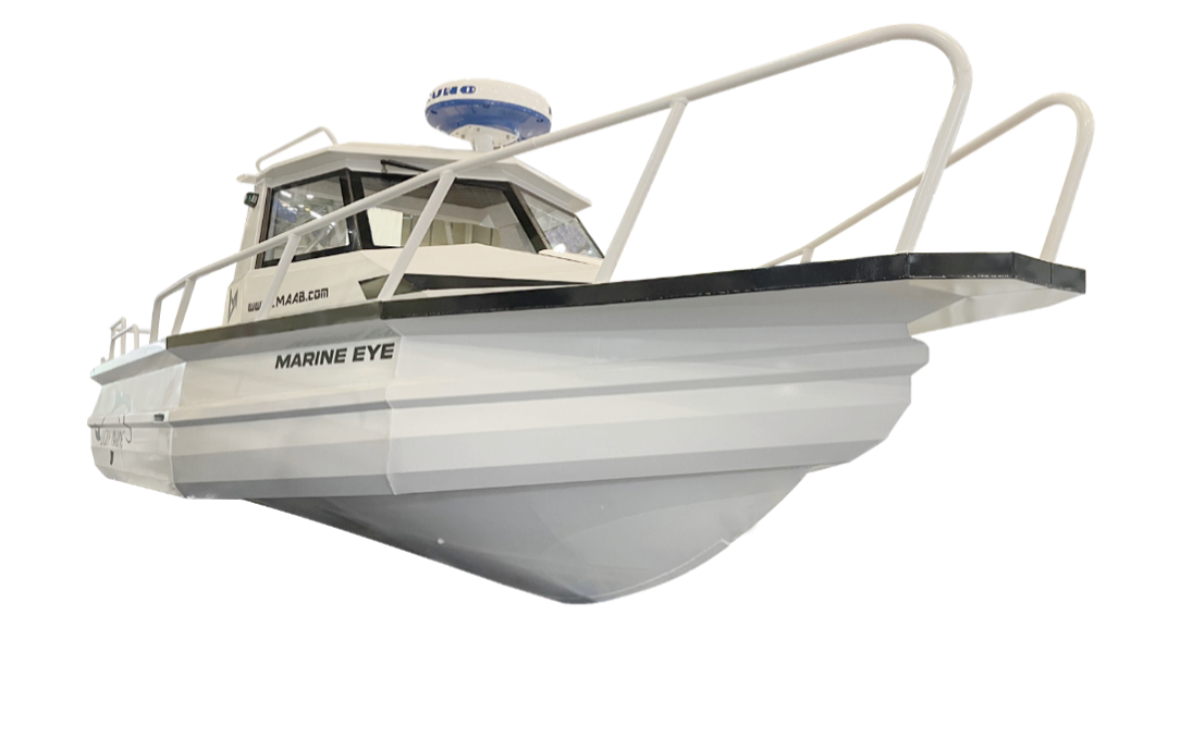
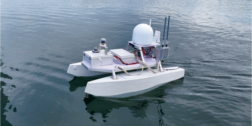
Multi-purpose Maritime Drone
The drone collects marine information such as temperature, salinity, sea bottom, etc and manages shore remotely with no human, automated.
Negotiable Min Order Quantity Unit
- Required Quantity
-
- Place of Origin
- South Korea
- Payment Terms
- Others
- Production method
- OBM
- Shipping / Lead Time
- Negotiable / Negotiable
- Keyword
- drone, marine & machine, monitoring system, marine electronics

JD Co.,Ltd.
- Membership
- VIP
- Recent Visit
- Jan 16, 2025
- Country / Year Established
-
 South Korea
/
2019
South Korea
/
2019
- Business type
- Manufacturer
Exhibition 2
ULSAN EXPO 2024- Verified Certificate
-
1

")
| Product name | Multi-purpose Maritime Drone | Certification | - |
|---|---|---|---|
| Category |
Electrical Equipment
Electronic Data Systems Environmental Products Water Safety Products Other Police & Military Supplies |
Material | - |
| Keyword | drone , marine & machine , monitoring system , marine electronics | Unit Size | - |
| Brand name | - | Unit Weigh | 0 kg |
| origin | South Korea | Stock | 0 |
| Supply type | OBM | HS code | - |
Product Information
Multi-purpose Maritime Drone
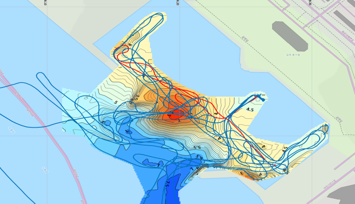
This is a multi-purpose maritime drone which collects various marine information such as temperature/salinity, sea depth, topography and takes videos with transmiting it to users.
It operates at any marine environment, including those that polluted or dangerous.
Users can manage their shore or sea farm with no human, remotely, automated, by this cutting-edge maritime drone.
Key Features
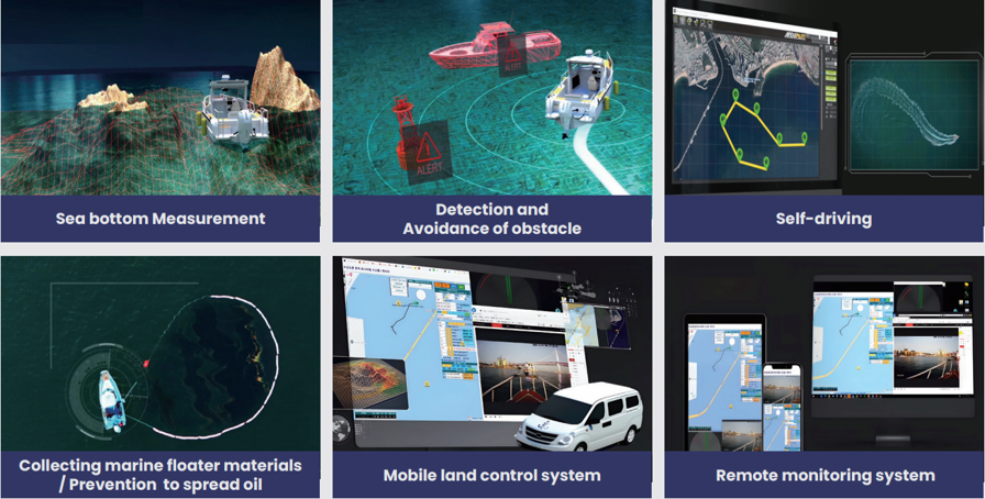
1. Real-Time Data Storage
- With a camera on the drone, users can check videos in real-time and save them in the middle of driving, and manage shore or sea farm.
- Through a sensor mounted on the drone, it collects marine information such as sea depth, temperature and deals with urgent situations.
- Equipped with ultrasonic radar and underwater sensors (such as water temparature, depth, and flow), the drone observes and analyzes weather and marine information and physical information (such as theft and physical damage) in real-time.
2. Remote System (Monitoring / Driving)
- Having a remote control system, the drone allows users to control movement and check marine information at any location they want.
- Including a 'way point function using GPS, it enables navigation to specific coordinates and travel routes designated by the user.
- With a 'Fail Safe' function, user can return the drone to designated safe location if communication doesn't work well due to an emergency situation.
3. Optimized Sturcture in Unstable Environments
- It controls the direction and stables its posture by itself with a rectangular structure like conventional ships, and also can recover quickly even if it is capsized, by its center of gravity.
4. Obstacle Avoidance Skill
- Developed technology for handling obstacles such as encountering floating debris or other vessels along a designated route.
- Applied unmanned ship obstacle detection technology for advanced autonomous navigation.
- Detecting obstacles and preventing collision through a sensor and control system.
- Enabled image rocognition through image vision technology which collects information and interpretates that.
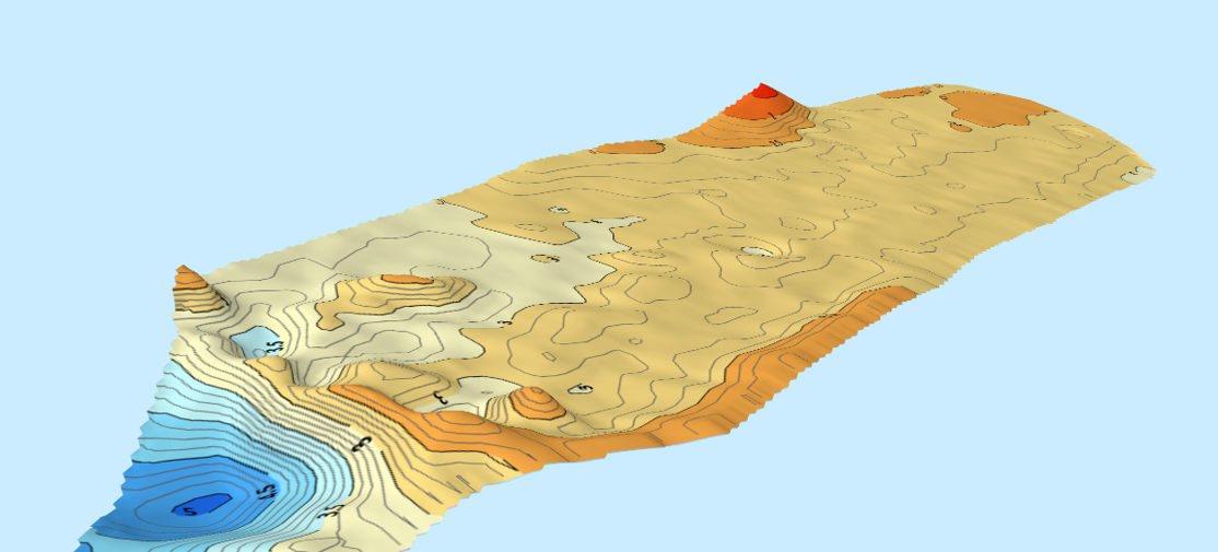
5. Unmanned System (Measuring / Observing)
- Unmanned marine drone to accurately and reliably survey seabed topography, replacing the traditional way of manned surveys in marine environments.
- Capable of utilizing real-time data through a mobile land-based control system.
- Protect the marine environment by recognizing marine debris and collectng coastal trash, and preventing oil spill dispersion.
- With various functions for coastal management, survey, rescue.
Specification
- Dimensions:1~5 (m) (Made-to-order)
- Communication Range: Approximately 100km (within LTE coverage)
- Maximum Output: 200HP
- Operational Time: 5-6 hours (at maximum output)
This is a specification of the basic maritime drone.
It can be changed according to the types of drones th at customers order.
B2B Trade
| Price (FOB) | Negotiable | transportation | Negotiation Other |
|---|---|---|---|
| MOQ | Negotiable | Leadtime | Negotiable |
| Payment Options | Others | Shipping time | Negotiable |
JD Co.,Ltd.
- Country / Year Established
-
South Korea
/
2019
- Membership
- VIP
- Recent Visit
- Jan 16, 2025
- Business type
- Manufacturer
Exhibition 2
ULSAN EXPO 2024-
1
- President
- Park Jung Geon
- Address
- 504, 22, Manggyeongnam-gil 44beon-gil, Jinju-si, Gyeongsangnam-do, Korea
- Product Category
- Other Machinery & Industry Equipment
- Year Established
- 2019
- No. of Total Employees
- 1-50
- Company introduction
-
- Main Markets
-
 Germany
 Indonesia
 Viet Nam
- Main Product


_2.jpg "Cable and Wire harness tester _MHT_610 _ 705__1")


